September 8, 2020
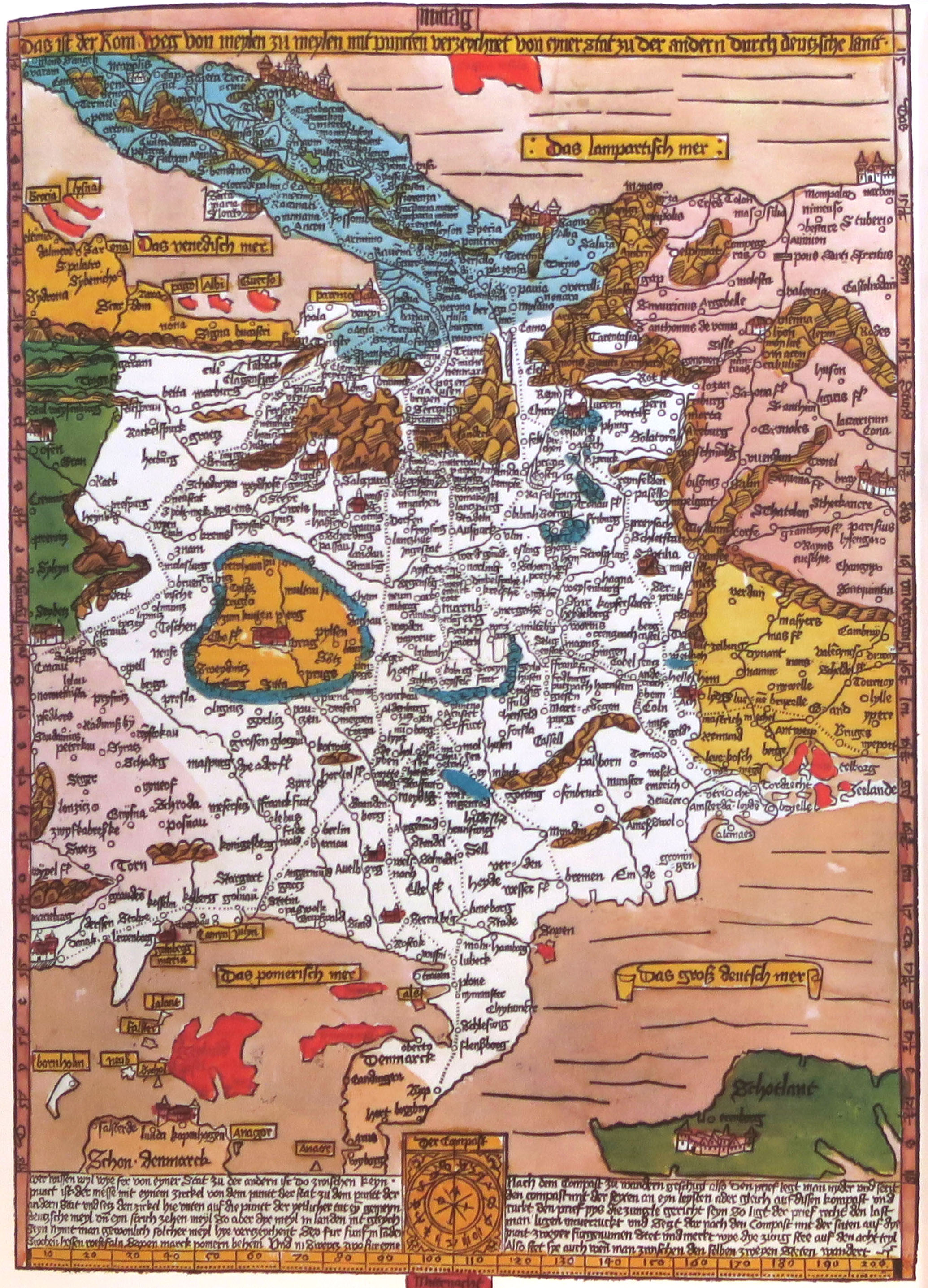
My interest in maps goes a long way back. But its most recent incarnation happened more than a decade ago when I realized I didn’t understand a map: ironically the first accurate map of Germany, the “Romeway Map” of Erhard Etzlaub, published in 1500. I didn’t understand its southern orientation—but that was easy to clear up. What caught my eye was that in its colored version, nations were set off from other nations. I had fully accepted the notion that nations were constructions of a later period. Nationalists make nations, not the other way around, Ernest Gellner famously asserted. But Etzlaub was no nationalist and the year was 1500. And yet here nations were being pictured on maps. Clarifying this problem for myself brought me down a path that led to Germany. A Nation in its Time. Before, During, and After Nationalism, 1500-2000.
I immersed myself in the history of cartography. I bought the available volumes of the authoritative History of Cartography, published by the University of Chicago Press. I read everything I could about maps of Germany in particular, including just about everything that a scholar named Peter Meurer had ever written. And I bought maps—the originals. My first dealer was Reinhold Berg in Regensburg. Soon there were others. I was hooked, yes addicted.
But addictions get expensive, and I’m just a professor. So at some point I started making maps myself. To do this, I learned how to use a fairly complicated program: ESRI’s arcgis for desktop. I lost some of my hair over this engagement, and when I look at the first maps I made (projections not right, elementary cartographic conventions not observed), I get embarrassed. But slowly, I got better. Now, to be sure, there are rock stars out there whose mapping abilities have attained an altogether different altitude than my own. But I had something of a niche. I made maps that others never bothered with (like mapping the places mentioned in the first dedicated geography of Germany—Johannes Cochlaeus’s Brevis Germaniae Descriptio, 1512). And this kind of mapping taught me something very valuable.
This is that most things are not mapped—the travels of Johann Ludwig Tieck and Wilhelm Heinrich Wackenroder in 1793 (the details of which were locked away for decades in the form of Wackenroder’s letters to his parents), for example. Some may find maps sketching out the travels of a poor student in the late eighteenth century superfluous, as did a reviewer of my book. But for me the very making of them helped me think about the experience of the early Romantics. Which towns did they visit? Which cave did they crawl into? Which castle ruin did they admire? The very act of mapping made it more concrete for me, and my historical imagination soon followed. It too became more concrete, more place centered, more conscious about spaces–and not just as pertains to literary figures, but also the events that bring us face to face with the murderous dimension of the German past.
I began to map out processes leading to the genocide, and to plot the places where it happened. I am hardly the first to do this. But again, the very act of plotting the places helped me to look closely. I tracked down all the communities in which synagogues were desecrated or destroyed during the Novemberpogrom of 1938, for example. I also charted the cities and towns in Lithuania in which the mobile killing units (and not just Karl Jäger’s notorious Einsatzkommando 3) massacred Jews, as another example. In my early efforts at Holocaust mapping, I certainly had help. Geoffrey P. Megargee, whose recent passing away is a huge loss for our profession, shared lists and coordinates of the ghettos and concentration camps surveyed in the US Holocaust Memorial Museum’s remarkable multivolume Encyclopedia of Camps and Ghettos, 1933 -1945. Ann Knowles and the team of scholars that put together Geographies of the Holocaust also gave me valuable advice on how to go forward. The most important thing, though, is the actual work of tracing each and every manifestation of whatever one is studying. It seems tedious. But the persistent focus on the question of “where” eventually reveals patterns.
It was in pursuit of one of these patterns that I started a new book project. I wanted to know where and when in the postwar era the artifacts of Nazi persecution in small-town Germany were being commemorated, and who was behind the commemorations. The project started with my mapping database of all the cities and towns in which synagogues were destroyed or desecrated, to which I added all of the communities that housed some kind of KZ subcamp. I began by visiting specialty libraries, like the Klau Library at the Hebrew Union College in Cincinnati and the Germania Judaica Library in Cologne, madly copying material on Jewish communities and their commemoration, literally starting with Acholshhausen in Lower Franconia and working my way through the alphabet. But then Covid struck, and the subsequent lockdown meant that I had to stop my work. And so I turned back to something I loved and could pursue while the physical libraries were closed. I turned back to my maps.
“German History Maps: The Essential List, 1500-2000” is the result of my love of maps and my attempts to make them. Some of the maps are period maps. Others are maps I have made. And still others are screen shots and links to wonderful on-line mapping projects. I continue to update the maps, and I continue to scour the internet for new projects. I have endeavored to construct the lists not in terms of the history of cartography, or as the standard-issue historical atlas might. Rather, I have tried to bring to the fore maps that would serve our community of teachers and scholars. Beyond that, I see the map lists as a first step towards an Atlas of German Studies.
I would be happy if fellow teachers and scholars use the maps and tell me of more they have found. I would also like it if people made requests. The first atlas ever made was Abraham Ortelius’ Theatrum Orbis Terrarum of 1570. It brought together mapmakers (Catholic, Lutheran, and Calvinist) from Holland, Germany, Italy, and elsewhere; it was, in short, a collaboration—a collaboratory, if avant la lettre.
Helmut Walser Smith, Vanderbilt University
From the Editors: We invite readers to visit Helmut Walser Smith’s mapping projects that are included in the Collaboratory.